New product for 2024: 3D Terrain Puzzles
Snowdon / Yr Wyddfa Terrain Puzzle - 6 Model Pack
£90.00
A 3D topographical model of the Snowdon Massif, made up of six parts.
Cumbrian Fells Terrain Puzzle - 6 Model Pack
£90.00
A 3D topographical model of Cumbrian Fells (including Scafell Pike), made up of six parts.
Our 3D terrain puzzles consist of six 95 x 95mm models that when placed together cover an area of 285 x 190mm, fitting within the footprint of an A4 piece of paper.
We’re currently offering four versions:
Models are available in grey or white, and are hand-finished for the highest quality.
The English and Welsh puzzles depict an area of 2.5 x 2.5km, representing a total area of 7.5km x 5km.
The Ben Nevis model represents an area 15km x 10km, with squares 5km x 5km.
Accompanying maps are used to help students arrange the models correctly. Please see free map downloads further down this page.
We’re currently offering four versions:
- Snowdon / Yr Wyddfa
- Cumbrian Fells (including Scafell Pike, Great Gable, Kirk Fell)
- Cadair Idris (Snowdonia, Wales)
- Ben Nevis
Models are available in grey or white, and are hand-finished for the highest quality.
The English and Welsh puzzles depict an area of 2.5 x 2.5km, representing a total area of 7.5km x 5km.
The Ben Nevis model represents an area 15km x 10km, with squares 5km x 5km.
Accompanying maps are used to help students arrange the models correctly. Please see free map downloads further down this page.
Ben Nevis (and surrounding area)


Cumbrian Fells (including Scafell Pike, Great Gable, Kirk Fell)


Cadair Idris (Snowdonia, Wales)


Snowdon / Yr Wyddfa (Snowdonia, Wales)


Accomanying maps, free to download
|
|
|
| ||||||||


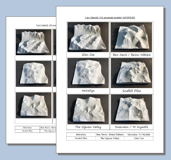
UK Mountain Models Education Pack 1
|
|
The UK Mountain Models Education Pack 1 is an engaging resource designed to help Key Stage 2 & 3 students understand how 3D topography is represented on 2D maps.
The Models
Scotland –
• Ben Nevis • Glen Coe - (The Three Sisters) England - • Scafell Pike • Helvellyn Wales – • Snowdon • Ogwen Valley (including Tryfan, Glyder Fawr & Llyn Idwal) The models are 10cm x 10cm and represent an area 5km square. With each 1cm representing 500m, this is the same 1:50,000 scale as the most common Ordnance Survey maps. The models are oriented with their sides matching North, South, East and West. Activity
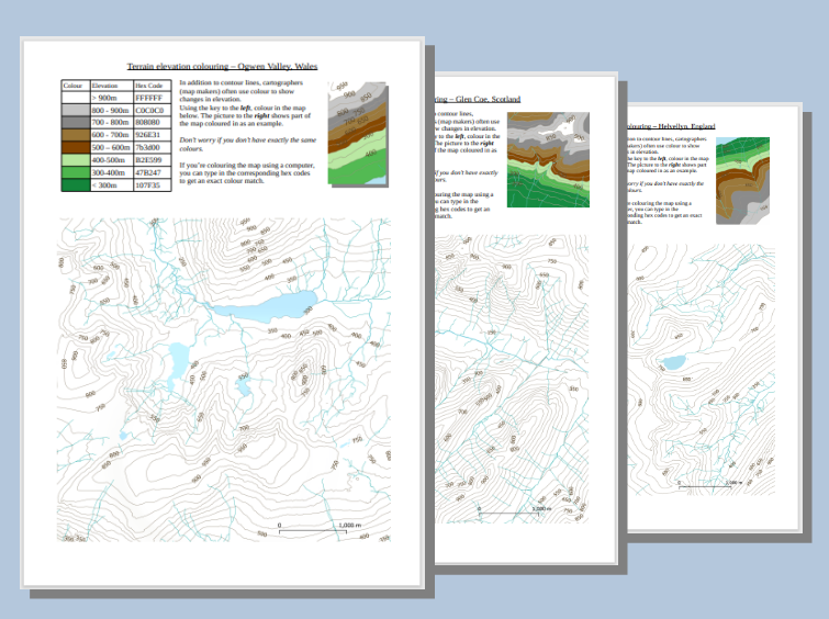
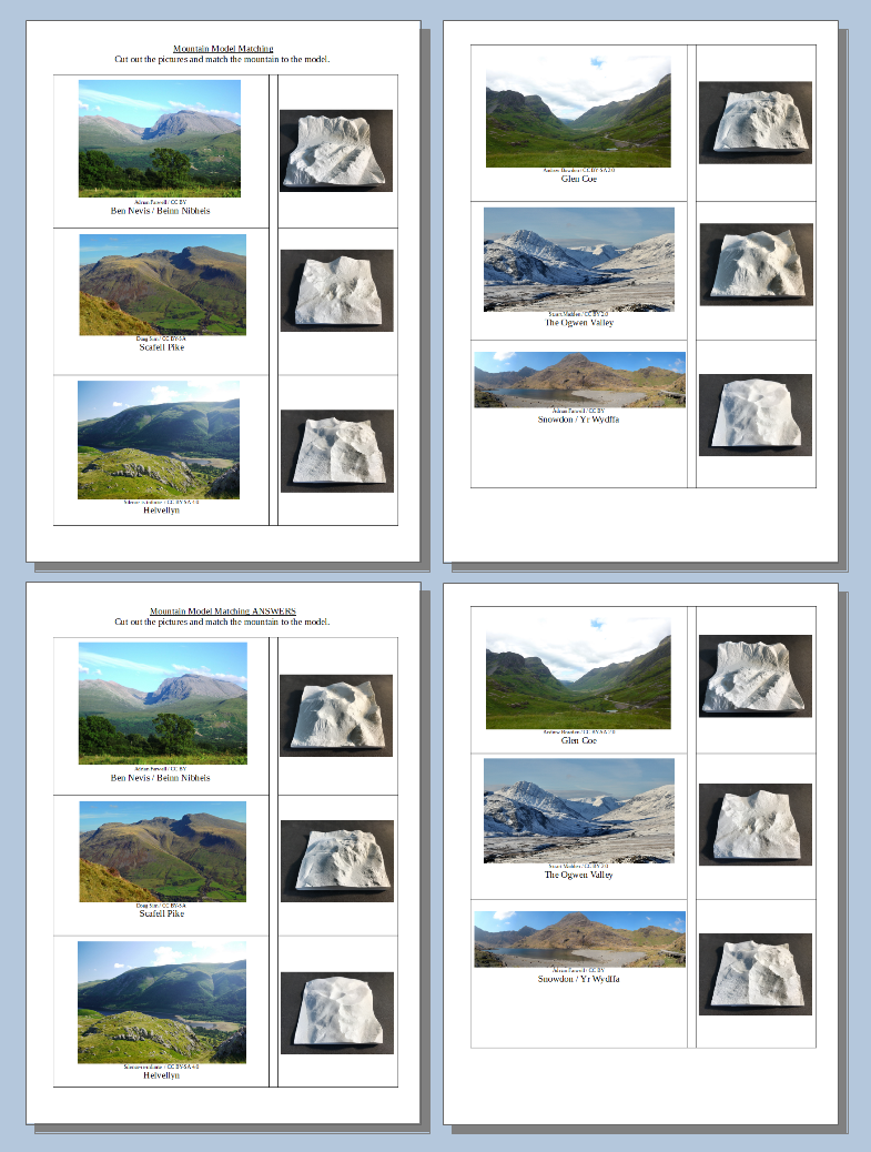
The main suggested activity requires students to match the 3D printed models to the corresponding 2D maps. Students may choose to challenge themselves by choosing the plain contour maps; others may choose the maps that include contour height labels and names.
The maps are from the Ordnance Survey’s Open Zoomstack project and are similar to standard OS maps. A zip file containing all map files and worksheets is provided free of charge with each purhcase (download link sent after checkout). A set of printed and laminated maps (eighteen 100mm x 100mm maps per pack) are offered as an option when purchasing the models. You can also download the maps for free below.
| |||||


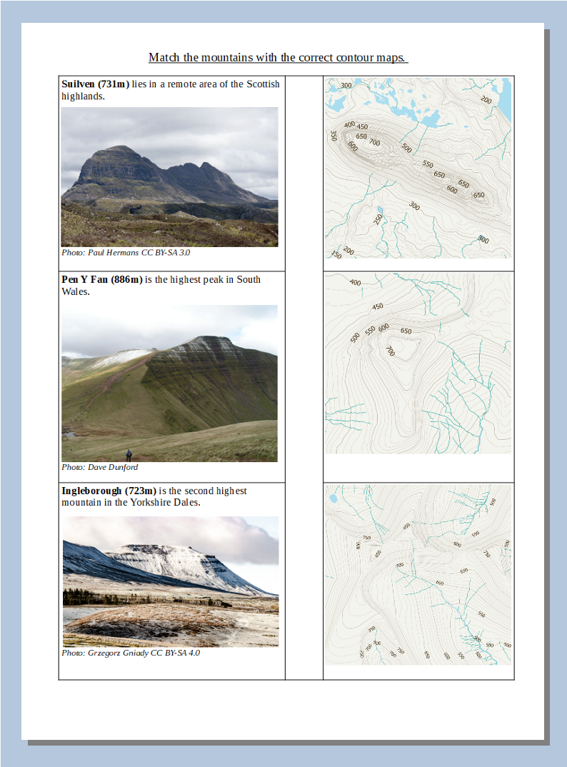
UK Mountain Models Education Pack Two - Suilven, Pen Y Fan, Ingleborough
|
Suilven
Ingleborough
Pen Y Fan
|
The Models
Scotland –
• Suilven England - • Ingleborough Wales – • Pen Y Fan The models are 10cm x 10cm and represent an area 2.5 km square. This is the same 1:25,000 scale as Ordnance Survey Explorer Maps, with each 1cm representing 250m. Click the link below to download the maps for free.
| ||


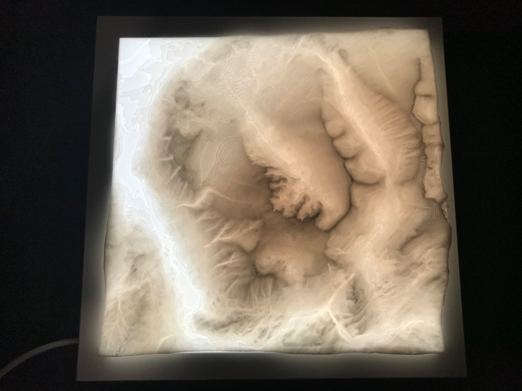
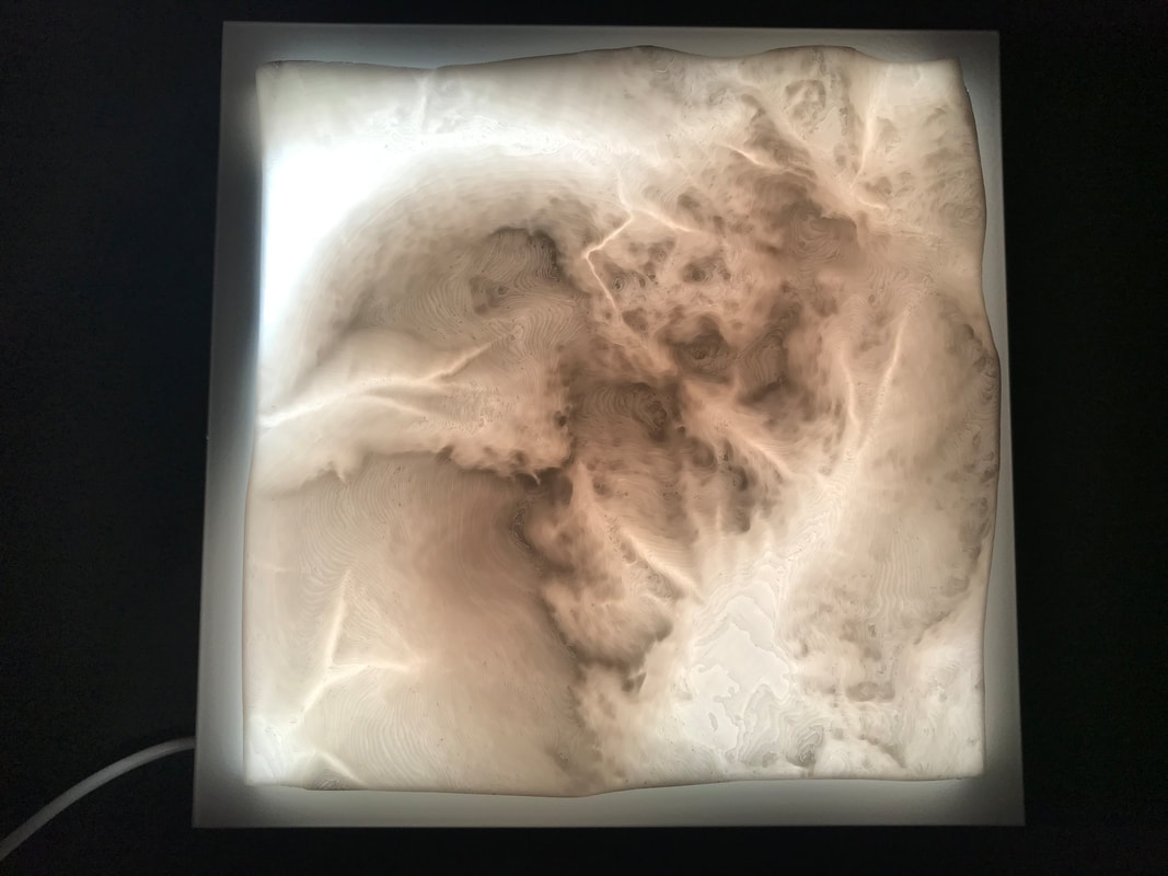
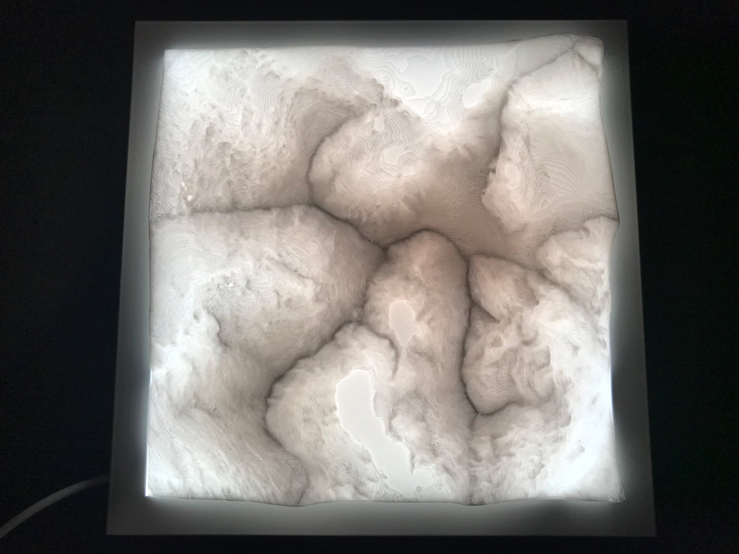
Large Models
We can supply large 189x189mm versions of any of the models featured on this page. When paired with one of our backlights, these models make beautiful lamps / night lights.
Model Dimensions: 189mm x 189mm (220 x 220mm including light base)
Includes 2m cable with mains USB adapter.
Includes 2m cable with mains USB adapter.
Pack 1 - Activities & Resources

|

| ||||||||||||||||||||||||||||||||||
Pack 2 - Activities & Resources
| match_mountains_photos_with_contour_maps.pdf |
Curriculum areas covered
The UK Mountain Models Education Pack covers the following areas of the KS1 and KS2 Geography Curriculum.
Locational knowledge
Locational knowledge
- name and locate counties and cities of the United Kingdom, geographical regions and their identifying human and physical characteristics, key topographical features (including hills, mountains, coasts and rivers), and land-use patterns; and understand how some of these aspects have changed over time.
- understand geographical similarities and differences through the study of human and physical geography of a region of the United Kingdom, a region in a European country, and a region within North or South America
- describe and understand key aspects of:
- physical geography, including: climate zones, biomes and vegetation belts, rivers, mountains, volcanoes and earthquakes, and the water cycle.
- use maps, atlases, globes and digital/computer mapping to locate countries and describe features studied.